Link your Mac with GPS receivers. Whether it’s a day hike, 4×4 excursion, geocaching quest, ski trip or sailing voyage — you’ll always know where you’ve been, where you are, and where you’re going.
- Flexibility: Support of open-standard format maps, aerial photos and charts, scan-your-own maps up to 32766 pixels wide, as well as our own maps and charts.
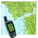
- Real-Time: Connect to NMEA from many GPS receivers. View your position and navigate to your destination on a wide variety of digital topo maps and marine charts.
- Waypoints, Routes, and Tracks: Create and edit. Use on the Mac. Transfer to and from smartphone apps, many Garmin receivers, and other software.
New features for version 10:
- Compatible with OS X 10.11 El Capitan.
- Auto-Open & Find-by-Location for New South Wales TopoView maps, Western Australia 50K & 25K topos, NZ Mariner charts, & the 2015 US Forest Service topos.
- Imports PDF map files at 250 pixels per inch, including VicMap (Victoria, Australia) 30K Geospacial PDFs.
- Reads GeoPDF, PRJ & EWW files for georeferencing.
- Reads KMZ files from Google Earth.
- Trims excessive white borders from map and chart files.
- Save only selected Waypoints, Routes, and Tracks.
- Use “Open Index Map” to quickly find a desired map
Requirements
OS X 10.4.11 or later
Screenshots

Download File
Size: 190 MB
Rapidgator Download |